Story time optional

Picture books you can read together on this site.

From the library

Free with a library card. Availability varies.

Follow That Map!: A First Book of Mapping Skillsby Scot RitchieBorrow in LibbyBorrow in HooplaRosie Revere, Engineerby Andrea BeatyBorrow in LibbyBorrow in HooplaWatch a read-aloud · Storyline Online

Standards this week

The same codes and I Can statements as the printed books.

Books by grade

Grade 1

  • 1.2I can distinguish exact and relative locations.
  • 1.2.3I can make a map with directions and symbols.
  • K-2-ETS1-1I can define a simple real problem, gather information and explain a proposed solution.
  • K-2-ETS1-2I can draw a design and explain how its shape helps it work.
  • K-2-ETS1-3I can test two solutions to the same problem and compare strengths and weaknesses.

Grade 2

  • 2.2I can distinguish exact and relative locations.
  • 2-ESS2-1I can develop and compare solutions that reduce wind or water erosion.
  • K-2-ETS1-1I can define a simple real problem, gather information and explain a proposed solution.
  • K-2-ETS1-2I can draw a design and explain how its shape helps it work.
  • K-2-ETS1-3I can test two solutions to the same problem and compare strengths and weaknesses.
Grade 1 Social Studies book, p. 27–28Grade 2 Social Studies book, p. 26–27
In your book

Session 1, Read and notice: Maps help people solve problems

Week 6 big question: Which design keeps more soil in place?

Start with a story (optional) Who's on Divya's Map? — Read it hereDivya draws a map with landmarks so her cousin Ravi can find his way.

A map helps people talk about a problem.

Imagine reaching a park path and finding mud across your way. Planners must solve this problem in our park. Then people can use the path easily again. Rain carries soil down a bare slope onto the path below. Before making a plan, they must find out just where the water goes. A map helps them show the slope. It also shows the part of the path that needs help.

A grid and key help us all find one spot.

But how can everyone find the same spot on the map? The planners add a grid with letters and numbers around it. Then “Path at B2” names an exact place they can all find. “Path below the hill” gives its relative location, using what is nearby. A north arrow helps everyone agree on which way to go. They check the key to read each symbol. The key shows the path’s line and the hill’s triangle. A blue arrow shows moving water. A title and date help them use the map.

Good planners test their ideas first.

Now the planners have two ideas to try for the path. They could cover bare soil to slow water. Or they could place a low barrier across the slope. Their criterion, or aim, is to keep soil off without blocking the path. Space and materials place a constraint, or limit, on what they can build. So they test small models, compare evidence, and improve their plans. Which plan will help people use the park again?

Look and think

Show what you notice

  1. What would planners need to know before they change the park?
  2. A design traps soil. Why might it still need to get better?

Answer your waypointact it outtell or dictatewrite

Grade 1 Science book, p. 17–19Grade 2 Science book, p. 30–32
In your book

Session 2, Investigate: Design, test, compare

A fair test changes only one thing.

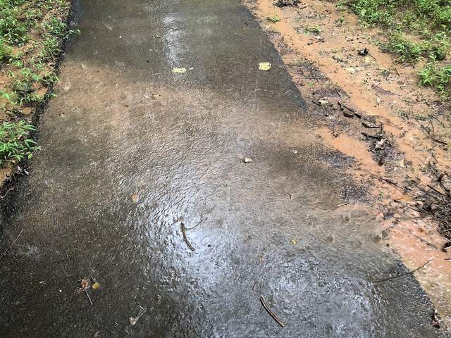
After rain, a muddy stream crosses a path you want to use. Where did all that soil come from in the first place? Flowing water can carry loose soil down a bare slope as runoff. Runoff is water that flows off the land. A cloth cover may help hold soil in place. Pebbles may slow the water. But soil can slip through gaps, so look closely at the runoff. Less muddy water suggests less soil washed away. Channels in the soil give clues, too. Our fair test keeps soil, slope, water amount, and pouring height the same. We compare designs with these things unchanged. What clues would make you choose one design over another?

Set up the test

Gather two shallow trays with adult-prepared drain corners · equal damp soil portions · loose-weave cloth scrap · small pebbles · measuring cup · two clear catch cups · towels and paper · paper strip marking the model path

Safety Adult prepares tray drains and controls pouring over a larger catch tray. Keep pebbles out of mouths; wash hands after soil handling. This is not a design for use near real waterways.

  1. Success means less soil moves and the path stays clear. Sketch a cloth cover and a pebble row.
  2. Mark the path on two matching soil slopes. Add one design to each. Guess which will work better.Adult: Make two equal slopes with the same soil and the same tilt.
  3. Watch an adult pour the same water on each, from the same low height. Catch the runoff in matching cups.Adult: Compare how muddy each cup is, and look for channels in the soil.
  4. Tell one strength and one weakness of each design. How would you make one better?Adult: If there is time, rebuild both the same way and test again to check.

Try the model

A model to try after your real test.

Getting the model ready…

Grade 1 Social Studies book, p. 29Grade 1 Science book, p. 20 and 22Grade 2 Social Studies book, p. 28Grade 2 Science book, p. 33 and 35

Session 3: Record and make — A planner’s map and recommendation

Compare · Design, test, compare

1Design A: cloth cover
2Design B: pebble row

Which cup looked less muddy

Add a dated daylight checkpoint on the daylight record, p. 234.

Fill this in on your workbook page.

A planner’s map and recommendation

Turn your test into advice for the made-up park. Use your map and your test to back it up.

  1. Draw a park map with a hill, a path, and a water arrow. Add a key, a north arrow, a title, and a grid.
  2. Give the path’s grid square. Then tell where the path is, next to the hill.
  3. Put your two sketches by the map. Pick one design, or say why neither is ready. Use what really happened.

Connect the ideas. How does the map help someone judge your choice? How does the test help?

Look closely

Tap a picture to make it big. Zoom in and find the clues.

PhotographMuddy runoff crossing a path, Virginia, 2021Famartin · CC BY-SA 4.0
PhotographRill erosion on a forest road, California, 2024Shopstone · CC0

Field trip

Visit with a grown-up. These open other websites in a new tab.

Grade 1 Social Studies book, p. 30Grade 1 Science book, p. 21Grade 2 Social Studies book, p. 29

My evidence page: My evidence-based design choice

Show both designs, their results, and your choice. Add a change you would test next. You may dictate labels or use arrows.

  • 1Both designs and their results
  • 2My choice and next change

3Choose and explain · Checkpoint game

Listen, then choose. Finish the game to earn this week’s stamp.

The game needs JavaScript turned on.

For the adult · what each grade shows

Grade 1

Show the path’s grid square and a relative clue, and tell one strength and one weakness of each design.

Grade 2

Explain which design you would choose, using the runoff and channel evidence from your fair test.

Showing the Grade 1 line for your book.

Showing the Grade 2 line for your book.

Take a photo of the evidence page or the test. Add your child’s own words. It stays on this device.

Add to my portfolio

Parent corner

How to run this week, in a few minutes.

At a glance

Time

From the workbook: Read and notice about 20 min · Investigate 20–30 min, plus short checks · Record and make 20–30 min.

Core

Run a fair test of two designs that slow runoff, and mark the path on a grid map.

Materials
  • two shallow trays with adult-prepared drain corners
  • equal damp soil portions
  • loose-weave cloth scrap
  • small pebbles
  • measuring cup
  • two clear catch cups
  • towels and paper
  • paper strip marking the model path
Safety

Adult prepares tray drains and controls pouring over a larger catch tray. Keep pebbles out of mouths; wash hands after soil handling. This is not a design for use near real waterways.

Short week

Read together, then do Investigate steps 1–4, Make steps 1–2 and the evidence page.

Next week

Add a dated daylight entry and compare with Week 1 without inventing a trend. Briefly retrieve the Great Lakes, rivers, or mountain ranges using the appendix.

Library books

  • Follow That Map!: A First Book of Mapping Skills by Scot Ritchie. Friends use different maps to solve problems and find their way.
  • Rosie Revere, Engineer by Andrea Beaty. A young inventor learns that testing and redesigning after a failed try is part of engineering.
Answer key (for grown-ups)

Talk together

  1. What would planners need to know before they change the park?
    Planners need the locations of the slope and path, water’s route, users’ needs, and available materials. Exact and relative descriptions help people discuss the same problem.
  2. A design traps soil. Why might it still need to get better?
    A barrier might obstruct access, redirect water badly, or need too many materials. Keeping soil in place is only one success criterion.

What to expect in the investigation

Cloth may reduce soil movement; pebbles may slow runoff yet allow sediment through gaps. Either result is possible. Wetness, fabric, pouring, and slope affect outcomes. Treat muddiness as a rough indicator, not a precise mass measurement. Children judge muddiness and channels by eye; eyes cannot weigh soil. A second test can check a surprising result.

Checkpoint question

Choice B. If needed, reenact an unfair comparison with unequal water amounts and ask what caused the different result.

Kindergarten this weekSocial Studies: Land and waterScience: Count our sky days