Story time optional

Picture books you can read together on this site.

From the library

Free with a library card. Availability varies.

Maps and Globesby Jack KnowltonBorrow in LibbyWater Is Water: A Book About the Water Cycleby Miranda PaulBorrow in LibbyBorrow in Hoopla

Standards this week

The same codes and I Can statements as the printed books.

Books by grade

Grade 1

  • 1.2.1I can locate community, California, United States, continents and oceans.
  • 1.2.2I can compare information from a three dimensional model and a picture.
  • 1.2I can distinguish exact and relative locations.

Science

Not in the Grade 1 Science book this week.

Grade 2

  • 2.2I can distinguish exact and relative locations.
  • 2.2.2I can label North America countries, oceans, Great Lakes, major rivers and ranges from memory; identify map elements.
  • 2-ESS2-2I can model landforms and bodies of water in an area.
  • 2-ESS2-3I can locate water on Earth in solid and liquid forms.
Grade 1 Social Studies book, p. 106–107Grade 2 Social Studies book, p. 108–109
In your book

Session 1, Read and notice: Routes, names and neighbors

Week 31 big question: What on a map helps us tell where a story took place?

Start with a story (optional) Who's on Divya's Map? — Read it hereDivya draws a map with landmarks so her cousin Ravi can find his way.

A map can help tell why a place matters.

Where will your trip take you, and what lies nearby? A map can help you find places and tell the story of your trip. It can also show a community or a resource that people share. Canada, the United States, and Mexico are three countries in North America. The continent also has Central America and the Caribbean. These places have many countries and island communities. As you look, notice how country borders differ from ocean coasts.

Learn where the oceans, lakes, rivers, and mountains are.

Let your finger travel around North America and find the oceans. The Pacific Ocean lies west, the Atlantic east, and the Arctic north. Then head inland to the Great Lakes: Superior, Michigan, Huron, Erie, and Ontario. Follow the Mississippi, Missouri, Rio Grande, and St. Lawrence rivers on our map. Look for higher land. Find the Rocky Mountains, Appalachian Mountains, and Sierra Nevada. Where you place each name matters more than a neat label.

The title, key, scale, and date help us read a map.

Before you follow a map, read its title to learn its subject. Then check the legend for symbols and the arrow for direction. To compare paper distance with real distance, use the scale. Check the date, too, to learn when the map was made or updated. An exact, or absolute, location names one place. A grid square or street address is an example. A relative location compares places, like “west of the library.” Which kind would help someone find your door?

Look and think

Show what you notice

  1. Why are Canada, the United States, and Mexico not all of North America’s countries?
  2. How could a map’s scale and date help you study an old trip?

Answer your waypointact it outtell or dictatewrite

Grade 2 Science book, p. 122–124
In your book

Session 2, Investigate: Land, water and useful models

A model and a map each show some things and miss some.

A lake is frozen on top, but what lies below the ice? Liquid water can still flow there under its solid lid. That lake holds water in more than one form at once. Elsewhere, oceans and rivers hold water, and so does the soil below your feet. Water is found below ground, too, while glaciers hold it as ice. Snow is solid water as well, just like the ice on a lake. A three-dimensional model shows hills and water, but blue paper cannot flow or freeze. So when you label water, think about what form it could take. Would you find liquid water, solid water, or both at different times?

Set up the test

Gather reference and blank maps from appendix · paper · blocks or reusable clay · blue paper · one safe local landscape view or photograph

Safety Use a safe indoor view or adult photograph. No visit to open water or mountain slopes is required. Do not use private addresses on a shared display.

  1. Pick land and water on a map or safe photo. Point to a hill or valley and the water.
  2. Build a three-dimensional model with blocks or clay. Use blue paper for water. Label land and water.Adult: Use reusable materials. Check that the main parts sit in the right places next to each other.
  3. Compare your model with the map. Record one thing both show, and one thing each shows better.
  4. Label where water could be liquid, and where it could be ice or snow. Which fit this season?Adult: Remind the child that the paper is a model, not real water.

Try the model

A model to try after your real test.

Getting the model ready…

Grade 1 Social Studies book, p. 108 and 110Grade 2 Social Studies book, p. 110 and 113Grade 2 Science book, p. 125

Session 3: Record and make — Remember, locate, explain

Remember, locate, explain

Use the atlas maps (p. 222), and learn one group of places at a time. Fixing mistakes is part of learning.

  1. On the world map (p. 223), find where you live. Find California, the United States, seven continents, and five oceans. Give an exact and a relative location.Adult: Check which places your school expects before scoring.
  2. Hide the map. On the blank maps, place the 23 countries of North America. Do it from memory, one group at a time.Adult: Groups: Canada, the United States, and Mexico; Central America; the Caribbean. These are independent countries, which rule themselves. The child may say names for you to write, from memory only.
  3. Add the oceans, Great Lakes, rivers, and mountains. Find the title, legend, arrow, scale, and date. Then check with the map.Adult: Mark each item remembered, helped, or needs practice. Retry missed groups later with no word list; picking from a list shows recognition, not memory.

Connect the ideas. What does your model explain that your map does not?

Look closely

Tap a picture to make it big. Zoom in and find the clues.

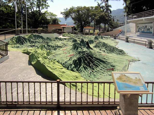
PhotographRelief model of El Salvador, 2012David Stanley · CC BY 2.0
PhotographInterstate 15 road signs, Utah, 2013Dougtone · CC BY-SA 2.0

Field trip

Visit with a grown-up. These open other websites in a new tab.

Grade 1 Social Studies book, p. 109Grade 2 Social Studies book, p. 111Grade 2 Science book, p. 126

My evidence page: A map with honest evidence

Add your memory map. Mark the help you got. Show how your land-and-water model is like a map. Show where solid water and liquid water can be.

  • 1My map and support record
  • 2Model and water evidence

3Choose and explain · Checkpoint game

Listen, then choose. Finish the game to earn this week’s stamp.

The game needs JavaScript turned on.

For the adult · what each grade shows

Grade 1

Show where you live, the continents, and the oceans, and one way your model and the map differ.

Grade 2

Explain which map places you named from memory and which ones still need practice.

Showing the Grade 1 line for your book.

Showing the Grade 2 line for your book.

Take a photo of the evidence page or the test. Add your child’s own words. It stays on this device.

Add to my portfolio

Parent corner

How to run this week, in a few minutes.

At a glance

Time

From the workbook: Read and notice about 20 min · Investigate 20–30 min, plus short checks · Record and make 20–30 min.

Core

Place North America’s countries and features from memory, in groups, and compare a model with a map.

Materials
  • reference and blank maps from appendix
  • paper
  • blocks or reusable clay
  • blue paper
  • one safe local landscape view or photograph
Safety

Use a safe indoor view or adult photograph. No visit to open water or mountain slopes is required. Do not use private addresses on a shared display.

Short week

Read together, then do Investigate steps 1–3 and practice one country group. If you skip world/community-location checks, exact and relative location explanations, water-form labels, and uncompleted memory/map-element checks, note it as “not yet” for your teacher.

Next week

Confirm the school’s expected country, river, and mountain-range set with your homeschool teacher before final scoring. The book’s broad study set is not an official school enumeration.

Library books

  • Maps and Globes by Jack Knowlton. Explains how maps show routes and places.
  • Water Is Water: A Book About the Water Cycle by Miranda Paul. Shows water on land and in the sky, as a model of the water cycle.
Answer key (for grown-ups)

Talk together

  1. Why are Canada, the United States, and Mexico not all of North America’s countries?
    The continent also includes Central American countries and Caribbean countries; the three core study countries are not an exhaustive list. Keep this context visible on the reference map.
  2. How could a map’s scale and date help you study an old trip?
    Scale estimates distance; date helps identify which boundaries or routes the map represents. Neither guarantees a traveler used a particular route.

What to expect in the investigation

Models should preserve major relative land-water positions. Height is easier to feel in a relief model; photographs can show surface appearance. Solid examples include glaciers and frozen lake surfaces; liquid examples include rivers, oceans, and groundwater. A model is not the real place. Glaciers are ice, and some lakes freeze on top with liquid water underneath. A label should say whether it means liquid water, solid water, or both at different times.

Checkpoint question

Choice B. Demonstrate the scale with a paper strip. Correct labels using the accurate appendix, not an illustrative sketch.

Kindergarten this weekSocial Studies: My year in orderScience: People change places